


Loading profile. Please wait . . .
Graptemys geographica (Le Sueur, 1817)
Northern Map Turtle


Federal Protection: No US federal protection
State Protection: Rare
Global Rank: G4G5
State Rank: SU
Element Locations Tracked in Biotics: Yes
SWAP 2015 Species of Greatest Conservation Need (SGCN): No
SWAP 2025 Species of Greatest Conservation Need (SGCN): Yes
2025 SGCN Priority Tier: Data Deficient
Element Occurrences (EOs) in Georgia: 12
Habitat Summary for element in Georgia: large streams and rivers
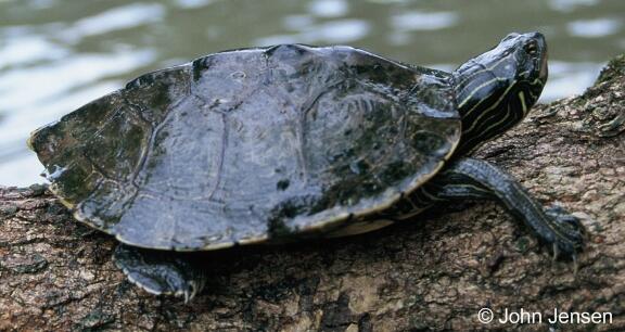
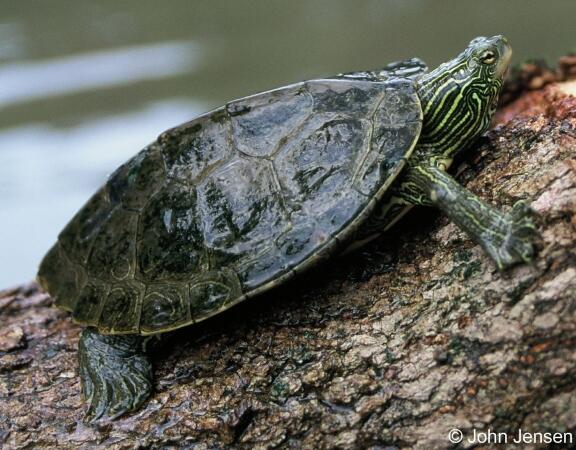
As this species was the first of the genus, Graptemys (meaning, “in scripted”), to be recognized by science (1817), the vernacular moniker of the so-named “map turtles” and the scientific epithet of this species in particular, geographica (meaning, “map-like”), is descriptive of the general map-like appearance of the carapace of many of the members of the genus and of the common map turtle especially. Like other species of map turtles, the common map turtle exhibits strong sexual dimorphism in both total size and head size. While males reach a carapace length of only 6 inches (15 cm), females may attain a carapace length of up to 10.5 inches (27 cm). In addition, females have a much broader head than do males. The carapace is olive-green, with fine, lighter green or yellow lines that form a reticulated pattern, similar in appearance to the contour lines of a topographic map. A low, vertebral keel is present, though not nearly as prominent as the keel found on other species of map turtles. Absent on adult females, low vertebral spines may be evident on the posterior portion of the carapace in both juveniles and adult males. The cream to yellow plastron is unmarked in adults, though the bridge and lower marginal scutes have longitudinal dark lines and circular dark markings, respectively. The skin is olive to dark-brown or black with many narrow yellow to light green stripes. Behind each eye is a small yet distinctive yellow spot, not connected to any of the stripes. Juveniles have dark markings along the seams of the plastron and a more intricate carapace pattern.
In Georgia, the common map turtle co-occurs within the Coosa River drainage with the Alabama map turtle (Graptemys pulchra), but the latter can be distinguished by their prominent spiny keel on the carapace (except old adult females) megacephaly of mature females, and the large yellow or light-green blotch present on the head between and behind the eyes; distinctive markings on the head are specific to each map turtle species and are a frequent means used in species identification.
Large streams and rivers with medium to fast current flow, an abundance of basking sites, and either exposed rocks or fallen trees and logs, are the preferred habitat for this species. Within Georgia, common map turtles are currently known only from such streams of the Ridge and Valley and Cumberland Plateau provinces. Elsewhere within its range, the common map turtle often inhabits large reservoirs and even small brooks.
Common map turtle forage during the day typically at depth of 3-6 feet of water collecting prey items from plants and submerged tree trunks or on the river bottom. Primarily carnivorous, the diet consists of primarily mollusks (females, both snails and bivalves; males, primarily snails); also fishes, crayfish, earthworms, aquatic insects, and some plant material. Adult males eat smaller mollusks and more insects than adult females. In addition to being larger than males, females have relatively larger heads, larger crushing surfaces on their more powerful jaws, allowing them to feed on larger, harder prey items, increasingly so with age.
Common map turtles spend a considerable amount of time basking on logs and rocks, but they will drop into the water at the slightest disturbance. Breeding occurs in both spring and fall, and nesting lasts from late May to mid-July. Females dig flask-shaped nests in soft soil or sand exposed to full sunlight and typically deposit 9-17 eggs. Up to three clutches may be produced by a single female each year. Although hatchlings begin to emerge in August or September, some may over-winter in the nest cavity and emerge the following spring. As with many other species of turtles, environmental sex determination also occurs in common map turtle. Incubation temperatures of 25 °C (77 °F) produce a predominance of males, while 30 °C (86 °F) or higher incubation temperatures result in a predominance of females.
Although basking traps may be effective, baited hoop traps, which are successful at catching many species of freshwater turtles, are not likely to capture many individuals of any map turtle species unless long fyke nets are used to draw them in. The most effective survey technique is visual surveys for turtles basking on exposed rocks or logs during warm, sunny days.
The common map turtle is the most widely distributed map turtle, ranging from southern Canada south to central Alabama and west to Oklahoma. In Georgia, this species is found within the Ridge and Valley physiographic province in the northwestern corner of the state within both the Coosa River drainage (a part of the larger Alabama-Mobile River drainage) and, the Chickamauga Creek drainage (a part of the larger Tennessee River drainage). Because both the common map turtle and the Ouachita map turtle (G. ouachitensis) are both known from Nickajack Lake of the Tennessee River it is plausible that these same species could also occur within Cole City Creek, a drainage in extreme northwestern Georgia flowing into this lake. However, the lack of permanent surface water within this stream channel likely explains the apparent absence of map turtles in this Georgia portion of the Cumberland Plateau. The lack of observations of the common map turtle from the upper stretches of the Coosa River in Alabama (and perhaps from other portions of this drainage), may be an artifact of incomplete sampling or may be reflective of the generally lower population densities of this species at the southern periphery of its distribution. Though the majority of the streams and rivers in which this species occurs drain into the Mississippi River, populations within the Coosa drainage and those of the northeastern states drain into Mobile Bay and the Atlantic Ocean, respectively.
A significant threat to common map turtles in is the decline or potential loss of their mollusk prey base as a result of stream degradation. Siltation, loss of stream-side shading, and various sorts of water pollution contribute to eutrophic conditions unfavorable to aquatic invertebrates. Illegal collection for the pet trade may also be threatening this species. The amount of egg and hatchling predation by raccoons is unknown but may be significant in areas of increased human activity.
This species is not currently documented from any public lands , however further survey effort may reveal presence of this species within the Conasauga River and on the Conasauga Wildlife Management Area. This species was protected under Georgia's Endangered Wildlife Act in 1992.
Riparian habitats of the Coosa River and Chickamauga Creek drainages should be protected from further degradation. Suitably sized forested buffers should be maintained or established where lacking along the banks of both the main channels and larger tributaries and removal of snags from stream channels should be discouraged.
More survey work is needed to determine whether this species occurs in portions of northwestern Georgia drainages. All larger tributaries of the larger Coosa River drainage including stretches of the Oostanaula River from Rome to Calhoun, and the entire length of the Conasauga River (where only a few scattered historical occurrences of the species are known) should all be targeted for survey. Additionally, the recent documentation of the Alabama map turtle from the Conasauga River in Tennessee brings credence to the possibility of the common map turtle’s plausible habitation of the larger tributaries making up the headwaters of this river.
Gordon, D. M. and R. D. MacCulloch. 1980. An investigation of the ecology of the map turtle, Graptemys geographica, in the northern part of its range. Canadian Journal of Zoology 58: 2210-2219.
McCoy, J. C. 1990. Grapemys geographica (Le Sueur), map turtle. Catalogue of American Amphibians and Reptiles 484.1-484.4.
Moulis, R. 2008. Common map turtle Graptemys geographica. Pp. 481-482 in Jensen, J. B., C. D. Camp, J. W. Gibbons, and M. J. Elliott (eds.). Amphibians and Reptiles of Georgia. University of Georgia Press, Athens. 575 pp.
Pluto, T. G., and E. D. Bellis. 1986. Habitat utilization by the turtle, Graptemys geographica, along a river. Journal of Herpetology 20: 22-31.
Pluto, T. G., and E. D. Bellis. 1988. Seasonal and annual movements of riverine map turtles, Graptemys geographica. Journal of Herpetology 22: 152-158.
Vitt, L. J. 1981. A survey of the status, distribution, and abundance of potentially threatened and endangered vertebrate species in Georgia, Part II: reptiles and amphibians. Unpublished report to Georgia Department of Natural Resources. 210 pp.
Vogt, R. C. 1981. Food partitioning in three sympatric species of map turtle, genus Graptemys (Testudinata, Emydidae). American Midland Naturalist 105: 102-111.
Vogt, R.C., Bulté, G., and Iverson, J.B. 2018. Graptemys geographica (LeSueur 1817) – Northern Map Turtle, Common Map Turtle. In: Rhodin, A.G.J., Iverson, J.B., van Dijk, P.P., Buhlmann, K.A., Pritchard, P.C.H., and Mittermeier, R.A. (Eds.). Conservation Biology of Freshwater Turtles and Tortoises: A Compilation Project of the IUCN/SSC Tortoise and Freshwater Turtle Specialist Group. Chelonian Research Monographs 5(11):104.1–18. doi: 10.3854/crm.5.104.geographica.v1.2018;www.iucn-tftsg.org/cbftt/.
White, D., Jr., and D. Moll. 1991. Clutch size and annual reproductive potential of the turtle Graptemys geographica in a Missouri stream. Journal of Herpetology 25: 493-494.
Thomas M. Floyd & John B. Jensen
J. Jensen, Dec. 2007: original account
K. Owers, Sept. 2009: updated status and ranks, added pictures
T. Floyd, Mar 2023: revised & updated the account